Geobotica GeoLidar
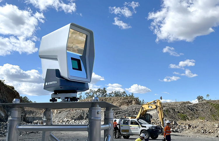
Geobotica GeoLidar is an automated LiDAR system for monitoring surface deformations in real time. Datasheet
Geobotica GeoLidar
GeoLidar uses a combination of rapid scanning and artificial intelligence to remove people, vegetation, moving vehicles, and other noise from its high-precision scans, allowing deformation and subsidence to be monitored with millimeter precision.
Unique Features
Rapid Scanning Technology: Rapid scanning allows moving objects to be identified and eliminated from the point cloud. GeoLidar takes just three seconds to capture 600,000 data points from a 70° x 70° field of view.
Progressive Mapping: With the smearing effects of motion removed, the system can map the point cloud to the surface. Successive scans fill in areas that were blocked by moving objects.
Settlement Calculations: With the surface map completed, the system can track the thousands of points making up the map, calculating settlement or deformation for each point with sub-millimeter resolution at shorter ranges and millimeter-scale resolution at longer ranges. All processing is done on-board the GeoLidar in real time.
Supporting Sensors: A built-in tiltmeter eliminates the need for leveling. A GNSS receiver provides a level of geo-spatial context to the data, and a 12 Megapixel camera contributes time-lapse photos.
Cloud Connectivity: Monitoring results are sent automatically to the cloud via a 4G/LTE link.
On-Site Configuration: A built-in WiFi hotspot allows smartphones or tablets to configure, start/stop, or reset the scanner.
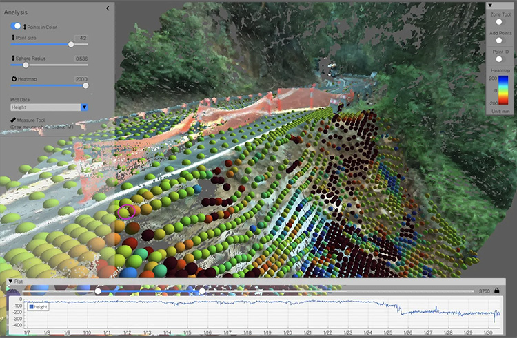
Benefit Short List: Full surface coverage, no reflectors or prisms needed, rapid deployment, minimal requirements for traffic control, safer and more reliable monitoring. Bundled GeoPoint software presents the scans in easily understood heat maps, trend plots, and tabulated data.

GeoLidar can monitor deformation in slopes, road surfaces, and rail corridors with millimeter precision. Its advanced on-board processing automatically removes people, trees, vegetation, vehicles, and machinery from scans and generates clean data for easily understood heat maps and trend plots.

GeoPoint software running on local PCs or in the Cloud, displays deformation data in easily understood heat maps. Clicking any point in the heatmap reveals a plot showing displacement over time. Selecting multiple point compares or averages measurements between points.
Geobotica specializes in sensing solutions that use Radar, LiDAR, Computer Vision, AI and Machine Learning and is a long-term partner of GEO-Instruments. Images and specifications courtesy of Geobotica.
